For avid hikers, the reasons to take to the trail are many. Trekking improves fitness, calms the mind, and elevates the mood. But if I’m being honest … I’m in it for the views.
Growing up in Vermont, my family hiked in the ancient Green Mountains, slogging up Camel’s Hump and tackling portions of the Long Trail. The views were wonderful, but they came at the expense of hiking for hours beneath the forest canopy. As much as I appreciate the hug of the spruce and sugar maple trees surrounding me on these outings, it was my first hike in the Pacific Northwest that revealed an alpine grandeur that broke open my outdoorsy heart. Here was a place I could hike along sheer rock faces, gasp at volcano views and cool off in hidden alpine lakes.
My view-finding leveled up on a recent visit to Glacier National Park in Montana, known for its epic vistas of ice-carved valleys and hanging glaciers. For those for whom a picture is worth a million words, this breathtaking park is not to be missed.
From glistening glaciers to turquoise lakes, we offer five spectacular places within the park that will render you speechless.
#1 Glacier’s Highline Trail
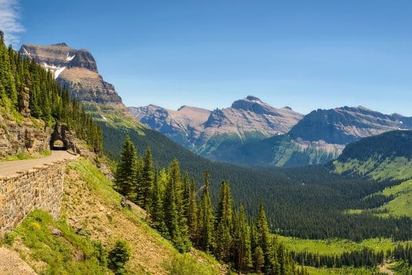
When it comes to bang for your hiking buck, Highline Trail in Glacier National Park pays out a handsome dividend. With a completely manageable elevation gain (think rolling, but rarely steep), this inclusive trail is a winner for most hiking fitness levels.
The Stats
- Start: Logan Pass Visitor Center
- End: The Loop (shuttle back to the visitor center)
- Distance: 11.8 miles one-way
- Elevation Gain: 1,950 feet
- Time to Hike: 6 to 8 hours
What You’ll See
The Highline Trail kicks off at Logan Pass Visitor Center with awe-inspiring panoramas. Within the first 2.5 miles, you’ll be treated to lofty views of the Lake McDonald Valley, the park’s iconic, glacially carved landscapes, and Mounts Oberlin and Cannon.
Keep trekking along a sheer rock face known as the Garden Wall (below you, the Going-to-the-Sun Road snakes its way up through the valley) until you reach the steep, rounded Haystack. Switch back to the top of this first real climb of the hike, then drink in the views of Logan Pass as you pause for refueling.
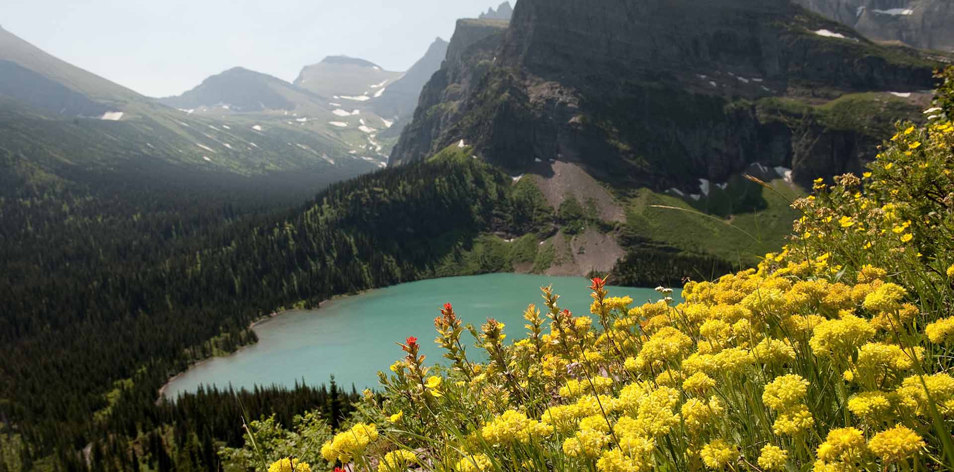
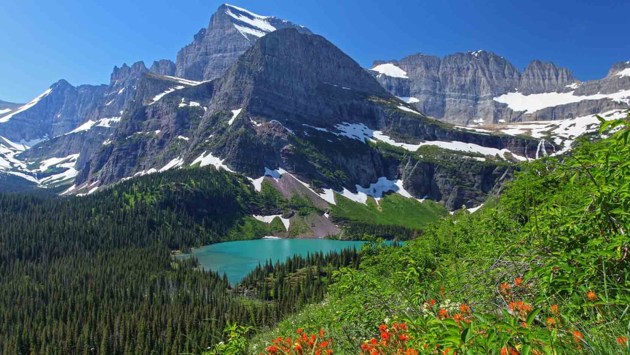
Press on to the highest altitude along the trail – around 7,175 feet – before descending to the Granite Park Chalet. From here, you can take the marked junction up a spur trail to reach Glacier Overlook and a satisfying vantage point over Grinnell Glacier, Grinnell Lake, and the park’s Many Glacier region. The main trail continues on to The Loop.
#2 Going-to-the-Sun Road
The Stats
- Route: West Entrance (32 miles to Logan Pass) to East Entrance (18 miles from Logan Pass), or vice versa
- Distance: 50 miles
- Highest Point: 6,646 feet
- Time to Drive: 2 hours (more with stops)
What You’ll See
This serpentine, super-scenic route is considered one of the best drives in the country, if not the world. Take turns driving (or take the park shuttle) so you have a focused driver and so everyone gets a chance to drink in the dizzying array of larger-than-life views.
Stretch your legs on a few short hikes to access incredible vistas along the route, including Trail of the Cedars, Avalanche Lake Trail, and the Grinnell Glacier Overlook.
If possible, time your drive to view the sunset at the Big Bend (just before Logan Pass Visitor Center if you’re driving eastbound). Take the short trail across from the parking lot for a top-down view of The Weeping Wall, known for its cascade of snowmelt. At the visitor center, consider a quick jaunt up to the Hidden Lake Overlook for a blissful alpine moment.
On the east side of Logan Pass, favorite stops on Going-to-the-Sun Road include Two Dog Flats, where roaming grizzlies are often seen; the Jackson Glacier Overlook, the best place to view a glacier from the road; and Logan Pass atop the Continental Divide, where you can often see mountain goats and bighorn sheep grazing in the wildflower-strewn meadows.
#3 Sun Point
The Stats
- Access: Sun Point Nature Trail in the Rising Sun Area
- Distance: 1.8 mile
- Elevation Gain: 216 feet
- Time to Hike: Less than 1 hour
What You’ll See
If you’re traveling eastbound on Going-to-the-Sun Road, you’ve crested Logan Pass and are now gradually descending toward East Glacier Park Village. To access Sun Point, park in the signed lot and head toward the trailhead in the southwest corner. Trails leave here for Sun Point, St. Mary Falls, and Virginia Falls.
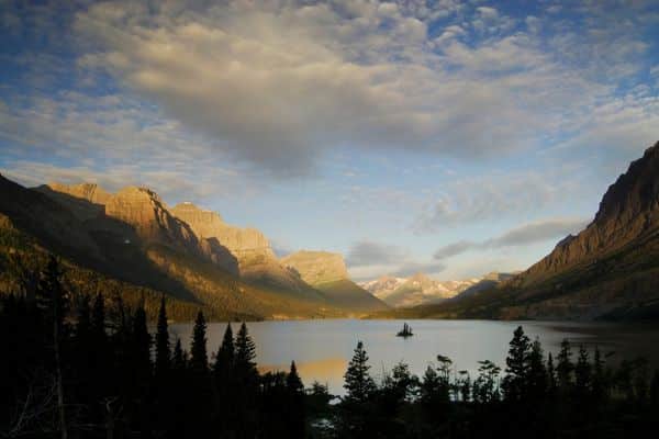
Sun Point itself is a small peninsula jutting into St. Mary Lake, from which you’ll get incredible water views and a 270-degree mountain panorama. From here, you can extend your hike to St. Mary Falls by following the trail along the lake shore. You’ll find yourself among stands of burnt trees, remnants of the Reynolds Creek Fire in 2015, before arriving at 25-foot Baring Falls. Pass the boat dock on St. Mary Lake, ascend a bluff for a pristine lake and mountain view, continue on to St. Mary River, then finally reach spectacular St. Mary Falls.
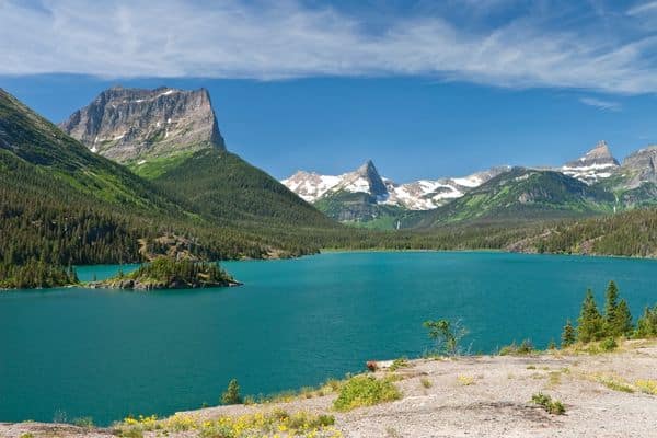
#4 St. Mary Lake
The Stats
- Location: Just inside the east park entrance
- Length: 10 miles
What You’ll See
This 10-mile-long lake is on the east side of the park, set along the Going-to-the-Sun Road. It’s a prime wildlife viewing location, including elk, mule deer, grizzlies, and black bears, and in the summer, it boasts a riotous display of colorful wildflowers along its shores.
A variety of day hikes start along the lakeshore and venture into the prairie and alpine landscape that surrounds it. Consider the 0.3-mile, one-way walk to Baring Falls, the 3.3-mile Beaver Pond Loop, or the more strenuous 9-mile roundtrip hike to Piegan Pass. Stunning St. Mary Falls can be accessed via a 0.8-mile one-way trek, losing 260 feet in elevation along the way.
Had enough hiking? St. Mary Lake is just as beloved for its scenic boat cruises, a relaxing way to appreciate the surrounding grandeur. Boat tours are generally available between June and September.
#5 Grinnell Lake
The Stats
- Start: Many Glacier Hotel
- Distance: 7.1-mile loop
- Elevation Gain: 351 feet
- Time to Hike: 2 to 3 hours
What You’ll See
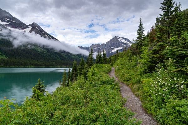
If you love a good alpine lake, don’t miss Grinnell Lake Trail. Depart from the Many Glacier Hotel on the northeast side of the park, first hiking alongside Swiftcurrent and Josephine lakes (or take a ferry to shave off some trekking mileage).
If hiking, start from the hotel along the Swiftcurrent Foot Trail, which winds through firs and lodgepole pines down to the water’s edge. The hulking pyramid-shaped Grinnell Point stands opposite you at the end of the valley. Continue along the water until you reach Lake Josephine, where you have two options for trails; for better views, take the North Shore Josephine Lake Trail along the lake’s northwest side.
When you come across the spur trail to the Hidden Falls Overlook, take it – this 0.85-mile detour to a 40-foot waterfall is worth the effort. Snap a photo, then continue along the main trail until reaching the gravel beach of Grinnell Lake. From here, you’ll have a perfect vantage point on the startlingly turquoise lake, overshadowed by the peaks of the Continental Divide and the Grinnell Glacier.
Are you ready to hit the trail for awe-inspiring views in Glacier National Park? Start planning your trip of a lifetime by contacting our Travel Experience Team.