The Cotswold Way Walking Trail & Hiking Guide
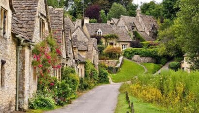
Walking the Cotswold Way is an unforgettable and scenic adventure along the iconic 102-mile route through classic English countryside. Set out from charming Chipping Campden and make your way (hiking at your own pace) to historic Bath, with historic stops along the way. Discover the sweeping views and enchanting villages, while being inspired by those who have traveled this special trail for centuries.
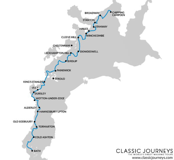
The Cotswold Way: Walking Route Map
Before you set off on your hike, it’s worth taking a little time to get familiar with what lies ahead on this long-distance trail. Using our Cotswold Way map, you’ll see the path of this timeless walking route marked with the villages along the way. This helps you visualize where you’ll begin and end, allowing you to plan your trek based on your pace and preferred village stops along the way.
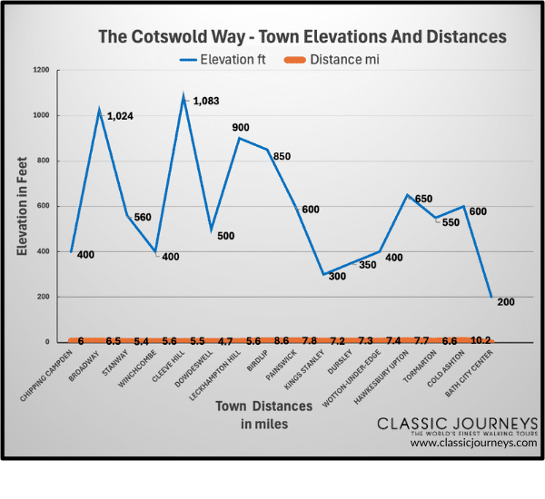
It’s a good idea to be prepared for the trail ahead, so learn more about the details of the terrain with our Cotswold Way elevation map. With marked distances between towns and a detailed elevation profile, you can see where the bigger gains and flatter stretches are along the route to better plan your trek. Get ready by gauging how difficult the Cotswold Way is based on your own fitness and hiking background. The trail is commonly described as “moderately challenging,” but that’s relative to your stamina in hiking long distances.
How to Walk the Cotswold Way
The chance to immerse yourself in the landscapes unfolding around you is why we think the best way to explore is on foot. This 102-mile trek is recommended in the direction of north to south, so you’ll want to begin in Chipping Camden and make your way down to Bath.
This gives you the opportunity to pause (briefly or overnight) at the towns in between as you pick your top sites to see and places to visit along the way.
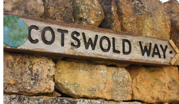
While this National Trail is maintained and well-marked with signs, be prepared to traverse through woodlands, up and down hills, through villages, and along open fields. Sturdy yet comfortable walking boots are a must, so lace up and break them in before you hit the trail.
Lastly, we recommend daily walks ahead of time to get used to longer strolls. Once you have your daily mileage mapped out, you can plan your overnight stops, start packing your backpack, and research the wildlife and historic sites that are of interest to you along the way. Depending on your pace and preferred stops, it could take one to two weeks to do the entire trek on England’s iconic trail.
Cotswold Way Route Descriptions: Distance and Elevation
The Cotswolds Way is a historic path of 102 miles with elevation gains and losses along the way and rising to its highest point at Cleeve Hill (1,083 ft). Each day, you can expect to walk up and down gently rolling hills while soaking in the sweeping views of England’s idyllic countryside.
Chipping Campden to Broadway
- Distance: 6 miles
- Elevation: 567 feet of ascent and 790 feet of descent.
Begin on the quaint streets of Chipping Campden and make your way into the countryside to Dover’s Hill. If you visit in late spring, catch the lively Olimpick games, which have been held here each year since 1612. Then make your way through open fields to get up close to the iconic Broadway Tower and into the town below.
Broadway to Wood Stanway
- Distance: 6.5 miles
- Elevation: 813 feet of ascent and 715 feet of descent.
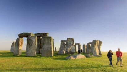
From the village of Broadway, set out on the path over gently rolling hills, past grazing cows and horses, and to the historic Iron Age fort of Shenberrow Camp. Continue into town towards Stanway Estate, a beautiful manor house with the tallest gravity fountain in the world.
Wood Stanway to Winchcombe
- Distance: 5.4 miles
- Elevation: 564 feet of ascent and 679 feet of descent.
Take the inclined path out of Stanway through fields and forests to the medieval ruins of Hailes Abbey. Stroll through farmland and into Winchcombe on Puckpit Lane, where local folklore claims that goblins dwell in the old quarry nearby.
Winchcombe to Cleeve Hill
- Distance: 5.6 miles
- Elevation: 1082 feet of ascent and 476 feet of descent.
Begin with a visit to Sudeley Estate’s castle and manicured gardens, then make the steady climb towards Belas Knap, a prehistoric burial ground built over 5,000 years ago. Continue onward to Cleeve Hill, the highest point along the route, to marvel at the panoramic views.
Cleeve Hill to Dowdeswell
- Distance: 5.5 miles
- Elevation: 325 feet of ascent and 604 feet of descent.
Make your way across the open fields of Cleeve Common and into nature, where you’ll follow the forested foothpath, pass fields of grazing cattle, as well as a butterfly reserve. Arrive at Dowdeswell Reservoir to spot wildlife such as the native white-clawed crayfish.
Dowdeswell to Leckhampton Hill
- Distance: 4.7 miles
- Elevation: 902 feet of ascent and 344 feet of descent.
Enjoy this section of shaded woodland as you walk among ancient trees towards Seven Springs, often cited as the original source of the Thames River. Enjoy views of the Severn Valley as you get to Leckhampton Hill and discover its unique rock formation called the Devil’s Chimney.
Leckhampton Hill to Birdlip
- Distance: 5.6 miles
- Elevation: Ascent and descent are almost equal at approximately 425 feet
Follow the tranquil trail to Crickley Hill and pause at the scenic lookout point above the Severn Valley. Then continue on through gently rolling fields to the grasslands of Barrow Wake, home to native birds and wildflowers, and into the charming village of Birdlip.
Birdlip to Painswick
- Distance: 8.6 miles
- Elevation: 590 feet of ascent and 1066 feet of descent
This portion of the path will take you through beech woodlands to Cooper’s Hill, which hosts the annual cheese-rolling event down its slope. Continue to Painswick, where you’ll arrive at the halfway mark of the Cotswolds Way.
Painswick to King’s Stanley
- Distance: 7.8 miles
- Elevation: 1033 feet of ascent and 1082 feet of descent.
Set out from Painswick across the gently flowing Wash Brook and through woodland to Haresfield Beacon, an Iron Age hill fort. Take in the scenery through Standish Woods to the historic canal of Stroudwater Navigation and into King’s Stanley, a lovely Gloucestershire village.
King’s Stanley to Dursley
- Distance: 7.2
- Elevation: 771 feet of ascent and 951 feet of descent.
Follow the Cotswold Way as it climbs through the countryside to Coaley Peak and through woodlands to Cam Long Down. The route gently descends toward Dursley, passing by an old quarry and scenic pastures along the way.
Dursley to Wotton-Under-Edge
- Distance: 7.3 miles
- Elevation: Ascent 835 feet descent 836 feet
This section of the trail offers an inclined walk to Stinchcombe Hill, with its beautiful views and diverse flora, then takes you along forested footpaths to the historic Tyndale Monument (dedicated to the martyr William Tyndale) and into Wooton-Under-Edge.
Wotton-Under-Edge to Hawkesbury Upton
- Distance: 7.4 miles
- Elevation: 984 feet of ascent and 623 feet of descent.
Leaving town, set out on a gentle climb to Newark Park for scenic views and to get up close to its impressive country estate from 1550. The path winds through fields and forests, giving you another incline to Somerset Monument and into Hawkesbury Upton.
Hawkesbury Upton to Tormarton
- Distance: 7.7 miles
- Elevation: 476 feet of ascent and 590 feet of descent.
This scenic section of the trail passes through fields and forests, heading towards the historic Horton Court, an ancient manor house, and then into lush farmland. Continue to Dodington Park, a stunning estate with manicured gardens, before reaching the quiet village of Tormarton.
Tormarton to Cold Ashton
- Distance: 6.6 miles
- Elevation: 558 feet of ascent and 410 feet of descent.
Leaving Tormarton, head south across open farmland and past Dyrham Park, a sprawling 17th-century house and garden set within an ancient deer park. From there, the trail continues through Dyrham Woods before gently descending into the village of Cold Ashton.
Cold Ashton to Bath
- Distance: 10.2 miles
- Elevation: 738 feet of ascent and 1312 feet of descent.
This final stretch of the Cotswolds Way begins in the open countryside before climbing past the historic grounds of the Battle of Lansdown. Soak up the views from Prospect Stile, where you can see Bath in the distance and arrive at the end of your journey.

Your Journey Along the Cotswold Way Starts Here
Before you hit the trail for your adventure along the Cotswold Way, be sure to use the resources on this page to guide you. Check out the helpful map, elevation guide, and walking descriptions between towns so you are well-prepared for your upcoming trek.
If you prefer the peace of mind that comes with having everything arranged for you, our Classic Journeys Cotswolds walking tour offers visits to Chipping Camden and Bath, daily curated walks through the stunning landscapes, and an expert local guide who’s right there to support you every step of the way. Learn more here!
Related Trips
Cotswolds Cultural Walking Tour
- 7 days
- Starting at $6,895